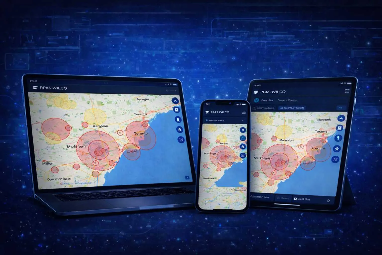
RPAS WILCO
Flight Planning App
The all-in-one platform trusted by Canadian drone operators for flight planning, compliance management, and real-time airspace intelligence powered by official NAV CANADA data.
RPAS WILCO Mobile App

Trusted by industry leaders across Canada
Everything You Need to Fly Legally
Built specifically for Canadian drone regulations. Stay compliant without the complexity.
Interactive Flight Planning
Plan missions with our powerful map interface. Draw flight paths, set waypoints, and visualize your entire operation.
Official NAV CANADA Data
The leading drone platform with official NAV CANADA aeronautical data distribution. Access aerodromes, airspace, VFR charts, and CFS data.
Site Survey in < 2 Minutes
Generate comprehensive site surveys quickly with official data, population density maps, and all required documentation.
Fleet Management
Track maintenance schedules, flight hours, and certifications for all your drones in one place.
Population Density Maps
Access detailed population density data to plan safe flight operations and understand your operating environment.
Compliance Reporting
Automatic flight logs, pilot records, and audit-ready documentation.
Airport Safety Management
A two-way coordination platform between drone pilots and partner airports — so flights near controlled airspace happen with shared awareness, not in the dark.
Built first for airports, now extending to defence facilities, correctional sites, and other sensitive-airspace operators across Canada.
How a coordinated mission works
- 01
Mission created
in the RPAS WILCO app
- 03
Notice received
airport context surfaced
- 04
Share details?
Yes — share No — fly anyway - 09
Acknowledged
adjust or proceed
- 02
Partner detected
auto airspace check
- 05
Details submitted
encrypted, stored securely
- 06
Airport alerted
structured mission data
- 07
Reviewed
in the airport portal
- 08
Response sent
in-app message
For drone pilots
- Advance airport notices for nearby controlled airspace
- Faster clearance through shared mission context
- Better airport coordination — your mission context reaches the airport directly, alongside your NAV CANADA authorization
- Audit-proof digital record — every coordinated flight kept on a permanent log
For partner airports
- Live visibility into drone activity near your airspace
- Direct two-way communication with operators
- Configurable notice rules per zone, runway, or time window
- One portal for all partner-pilot coordination
Partner airports across Canada
Eight airports already on the network — and growing.
Click any airport for runways, specs, and partnership info Pinch to zoom, drag to pan, tap an airport
Are you an airport, defence facility, or restricted site?
Join the Airport Safety Management network. We'll handle the integration; you get visibility, coordination, and a direct line to drone operators in your airspace.
Earn Wilcoin, Unlock Rewards
Every flight, mission, and milestone earns you Wilcoin — our in-app currency you can redeem for upgrades, perks, and exclusive gear.

Earn
Complete missions, file site surveys, refer fellow pilots, and maintain daily streaks to stack Wilcoin.
Spend
Redeem for Pro upgrades, partner discounts, premium features, and exclusive RPAS WILCO gear.
Grow
Higher tiers unlock bigger rewards, leaderboard visibility, and exclusive perks for top pilots.
How It Works
Get from planning to flying in three simple steps.
Plan Your Mission
Use our interactive map to draw your flight area, set altitude limits, and check airspace restrictions.
Generate Documents
Automatically create site surveys and all required compliance documentation in under 2 minutes.
Fly With Confidence
Execute your mission with official NAV CANADA data, airspace alerts, and automatic flight logging.
Simple Pricing
Choose the plan that fits your needs.
Ready to Run Missions in the RPAS WILCO App?
Join 50,000+ pilots who trust RPAS WILCO for flight planning and compliance.
RPAS WILCO Mobile App
Trusted by 50,000+ drone pilots across Canada · Official NAV CANADA Data Distributor